06 November 2025 – Press release | Download pdf
Authors: Chiara Richiardi, Letizia Caroscio, Edoardo Crescini, Massimo De Marchi, Giovanni Marco De Pieri, Christopher Ceresi, Federico Baldo, Matteo Francobaldi, Salvatore Eugenio Pappalardo
From the collaborative work of the SCIFT Laboratory (Officina di Scienza, Climattivismo, Immaginazione, Formazione e Tecnologia) Laboratory, space of convergence for activists and accademics from different universities (Bologna, Torino, Padova, Parigi) and research institutions (ENEA), and the Centre of Excellence Jean Monnet on Just Fossil Fuel Transition of Padova University (ICEA Department), a scientific article titled “A Global Approach to Mapping Surface Urban Heat Islands Using Open Data and Collaborative Technology” was published on 6 November 2025 in the peer-reviewed journal Journal of Sustainable Geosciences: People, Planet and Prosperity (Elsevier, 2025).
This open-access article presents the first global open-source algorithm for analysing urban heat islands and climate extremes in the urban context. The research The research stems from a growing need to create inclusive pathways for the democratization of scientific knowledge through the use of data and technology, aimed at developing strategies and plans that enable cities to respond proactively to extreme weather events and their impacts on urban environments (Figure 1).
According to the new report “Soil sealing, terriorial dynamics and ecosystem services” published by ISPRA at the end of October 2025, soil sealing remains one of the most pressing challenge in Italian urban contexts. In 2024 alone, more than 83 km² of soil were sealed, with a net consumption of 78,5 km² (the highest value recorded in the last twelve year ), equivalent to nearly 8000 hectares.
Emilia-Romagna, located in the middle of Padana Plan, emerges as one of the most affected regions, with 1013 hectares of newly artificial surfaces and a total share of consumed soil equal to 8.9% of the regional territory, exceeding the national average of 7.2%. In Bologna, urbanized space continues to expand (+16 hectares in the city and over 120 in the province in the last two year), while the termal anomalies between urban and rural areas is widening, indicating an intensification of the urban heat island. These data higlights the significant shortcomings of the regional law against soil sealing, which in practice acts as a driver of urban sprawl and the degradation of urban ecosystem.
The snapshot provided by ISPRA further demonstrates and reinforces the importance of analytical tools designed to assess the impacts of climate change in service of the community, tools that help collectively envision urban alternatives centered on the needs and priorities of the most vulnerable and marginalized populations.
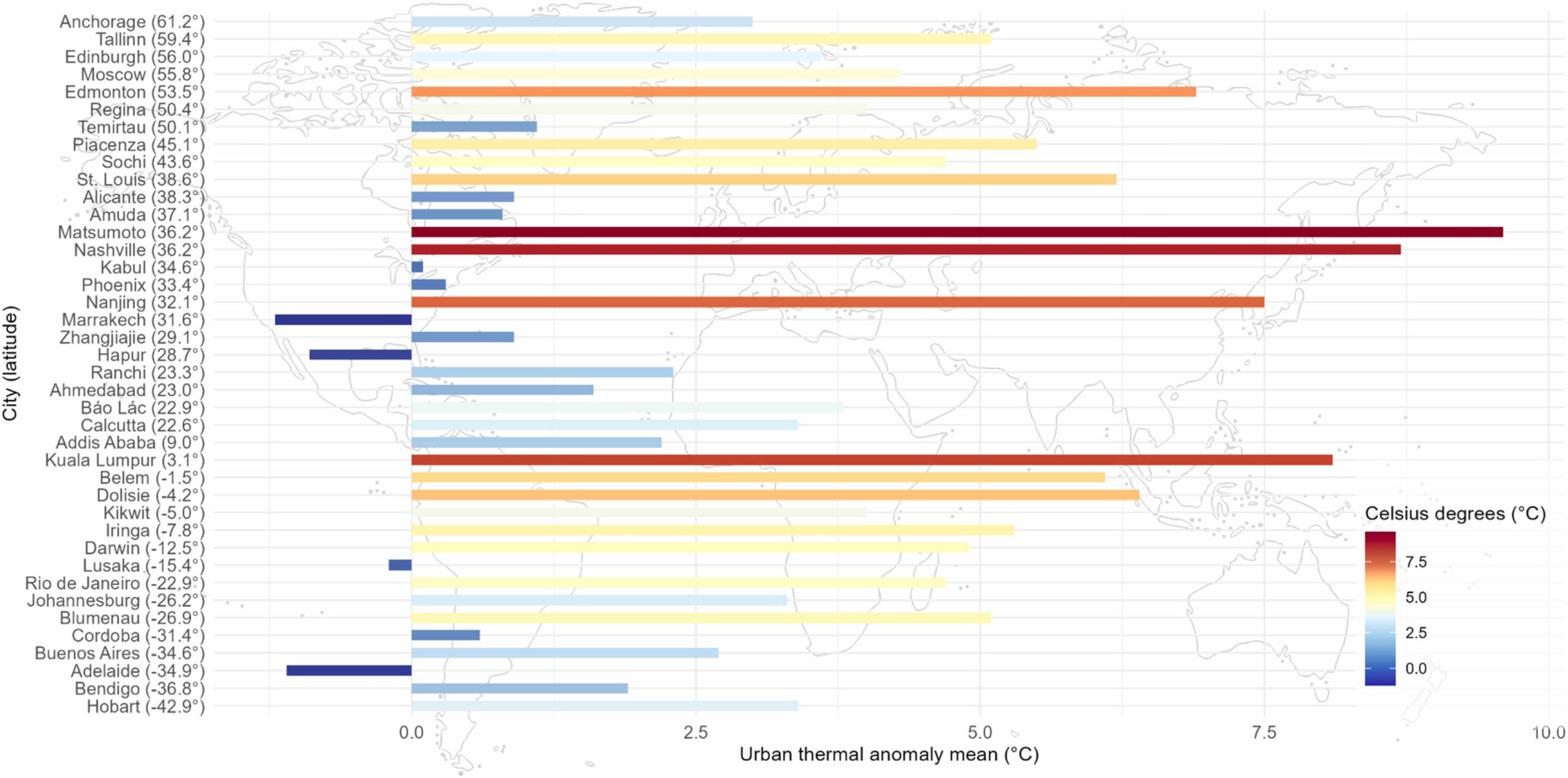
This research, also presented in Vienna at the ESA (European Space Agency) Living Planet Symposium 2025, emphasizes a citizen science and cooperative approach aimed at actively contributing to the development of practical tools that can support urban decision-making processes in the context of the climate crisis, making them more inclusive and better aligned with the needs of both the urban ecosystem and its inhabitants. The algorithm, written in R and Python and freely available on GitHub – Officina SCIFT, relies exclusively on open data sources, including thermal radiance (°C) from Landsat satellite imagery, altitude (m a.s.l.) from SRTM, and land cover data from OpenStreetMap. It produces four main outputs:
- the warm-seasonal LST mean, in °C, i.e. the warm-season mean aggregation of the available LST scenes’ valid pixels;
- the metrics SD and IQR, in °C, to provide stability metrics;
- the thermal anomaly intensity (or SUHII) map, in °C, i.e. the absolute temperature anomalies between the urban and the surrounding rural areas;
- the SUHIIindex map, 0 – 1, dimensionless, i.e. the normalized value of the thermal anomaly intensity (Figure 2)
The growing loss of green spaces and the increasing climate risks faced by cities make this algorithm a solid scientific foundation for collective action and for the development of data-driven, equitable urban policies. By being made open-access, the algorithm reduces technical and scientific barriers and promotes a public and transparent use of climate data. It enables the identification of neighbourhoods vulnerable to heatwaves, the estimation of proximity to green areas, and the support of urban adaptation strategies. The code seeks to foster an alternative vision of urban planning and design, one that is inclusive, fair, just, conscious, and solidaristic, grounded in climate justice and human rights. It places at its core the mutual relationship between human society and ecological systems, promoting a model of coexistence based on interdependence and care
