Unburnable carbon in the rapidly warming Arctic: mapping spatial relationships among oil and gas development, ecologically sensitive areas and Indigenous Peoples’ lands
22 April 2026 – Press release | Download PDF ( ENG | ESP | ITA )
Authors: Daniele Codato, Daniele Vezzelli, Federica Ammaturo, Giorgia Lazazzera, Andrea Stralla, Salvatore Eugenio Pappalardo, Massimo De Marchi
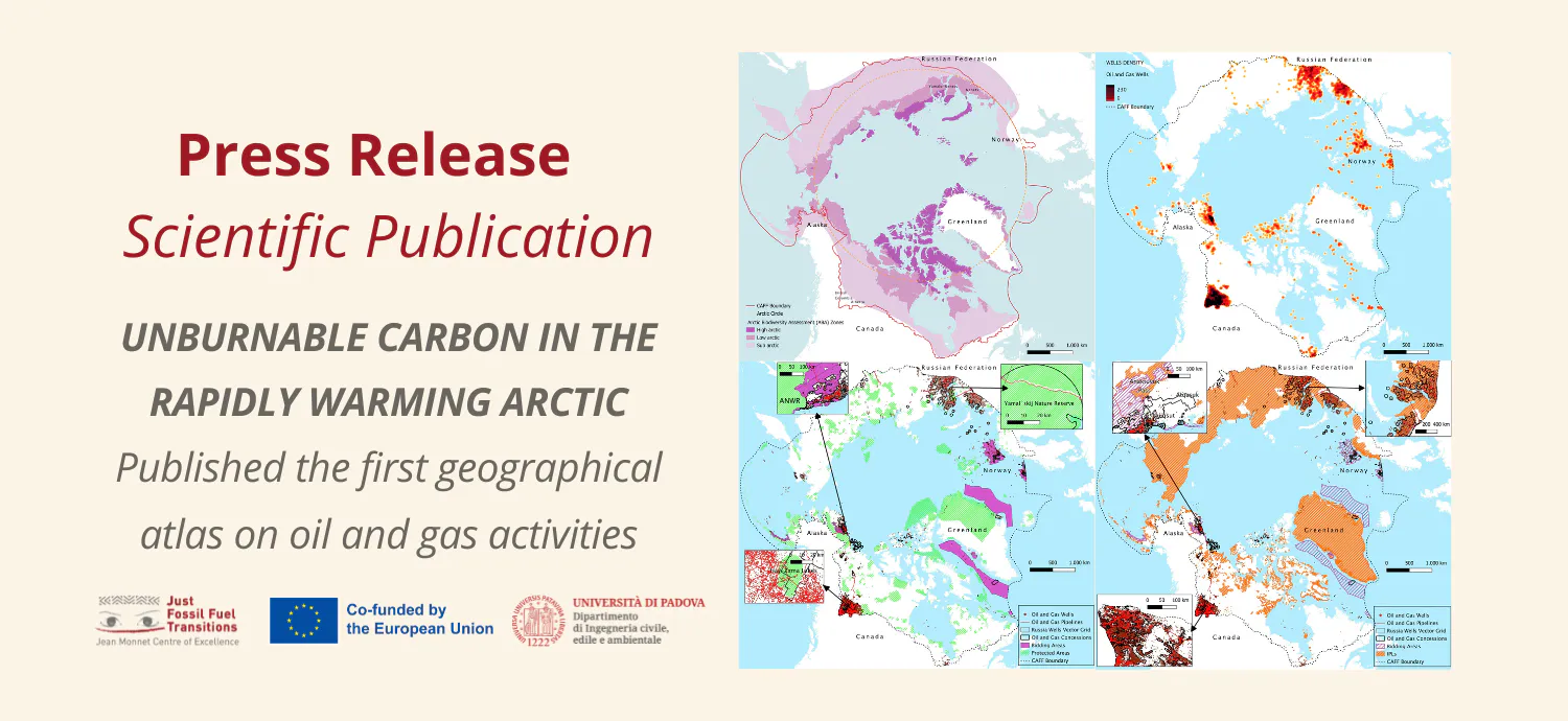
A new study published in PLOS One and led by researchers from the Jean Monnet Centre of Excellence on Just Fossil Fuel Transition and the international research group “Climate Change, Territories, Diversity”(Dep. ICEA) at the University of Padua presents the first comprehensive geographical atlas of oil and gas across the Arctic.
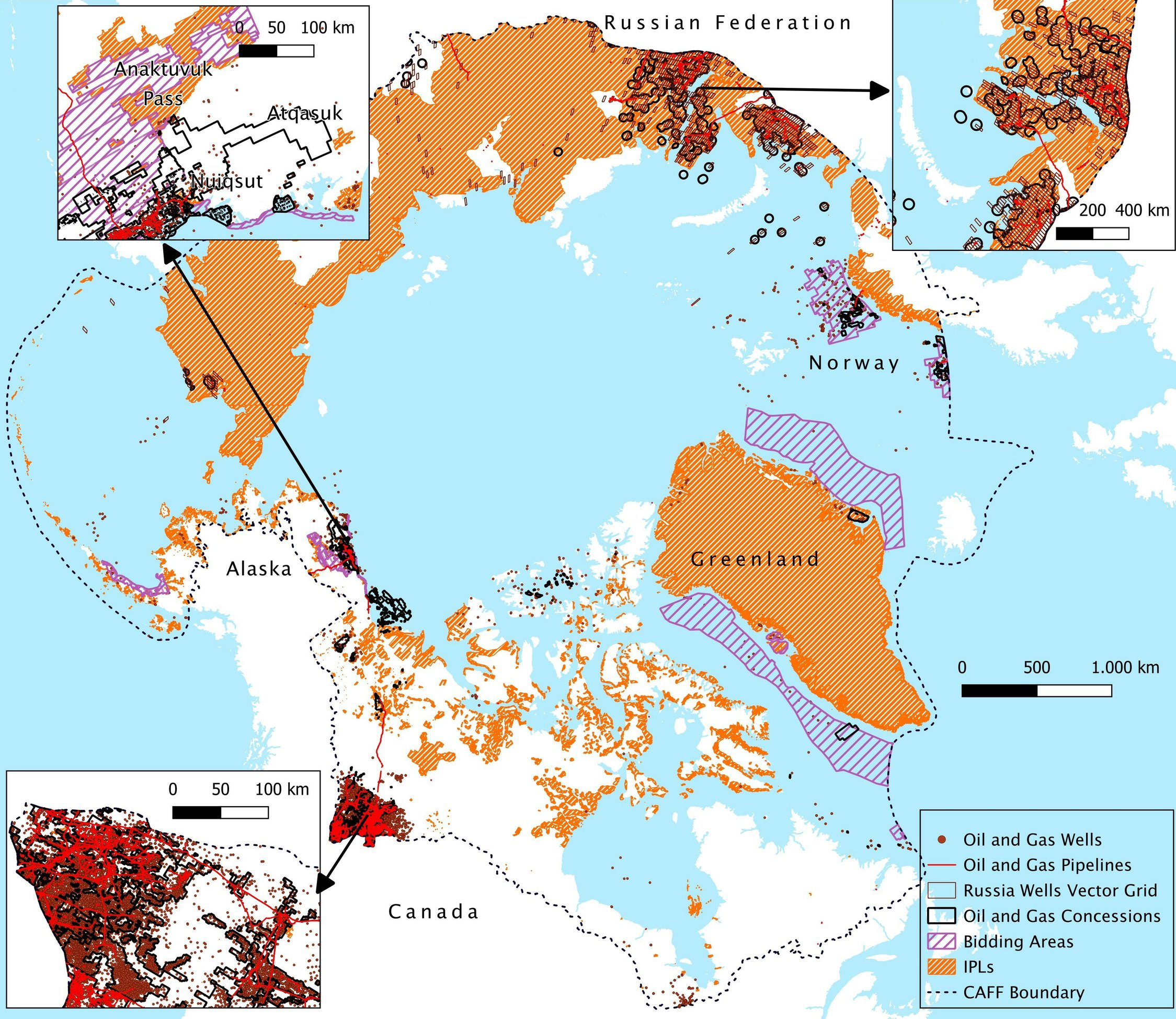
The research maps the distribution of oil and gas licenses and infrastructure across the Arctic using open-access geospatial data from five Arctic countries: USA (Alaska), Canada, Greenland, Norway and Russia. Through a place-based geovisualization approach and GIS analysis the atlas shows how these developments intersect with ecologically sensitive areas and Indigenous Peoples’ lands.
The study is released at a critical global geopolitical phase, marked by military escalation and unfair international relations that fuel the dynamics of fossil capitalism, in which the Arctic region represents a key hotspot. Indeed, it is warming nearly four times faster than the global average, marking the frontline of both climate change impacts and oil & gas development and opening new frontiers for resource extraction and shipping, thereby intensifying environmental degradation.
These aspects have renewed geopolitical interest among empires, accelerating the rush to control the region and its resources, eroding decades of international cooperation to conserve and protect these fragile and vulnerable ecosystems. Clear evidence is represented by the pressures of the new imperialism from Trump’s United States on Greenland, where U.S. resource grabbing and strategic military positioning is challenging the island’s sovereignty and exacerbating geopolitical tensions among global powers.
In this unstable geopolitical context, the climate crisis risks moving to the background. Yet, to stay within the 1.5 °C Paris Agreement target, profound and immediate action is required, with a large share of the oil and gas reserves that must be kept underground and undeveloped, what literature defines as “unburnable carbon”. Arctic oil and gas resources are among the most technically challenging to develop, with different studies which identify this region as an area where oil and gas resources should remain entirely untapped based on economic viability and carbon-intensity criteria. Moreover, the expansion of oil and gas infrastructure such as pipelines, wells, and seismic surveys can fragment habitats, disturb wildlife, alter migration routes, and disrupt traditional subsistence activities, including hunting, fishing, and reindeer herding.
By making visible the spatial relationships between extraction activities, ecosystems, and Indigenous territories, this atlas provides updated cartographies for policymakers, researchers, and communities seeking to guide sustainable land-use planning and climate action in one of the world’s most vulnerable regions. In this regard, the research employs geographical criteria such as protected areas, NGOs conservation zones, the distribution of key Arctic species and Indigenous Peoples land to identify and geovisualize priority areas where fossil fuel resources should remain underground, based on these spatial justice criteria.
The study
Given the study’s focus on socio-cultural dynamics and ecosystem conservation, the limits of the Arctic region considered in the study were defined according to the boundaries established by the Conservation of Arctic Flora and Fauna (CAFF) working group of the Arctic Council, which combine climatic and bio-geographical criteria. CAFF boundary is wider than the Arctic Circle and the tree line, including a greater portion of territory, most of all in Canada and Russia.
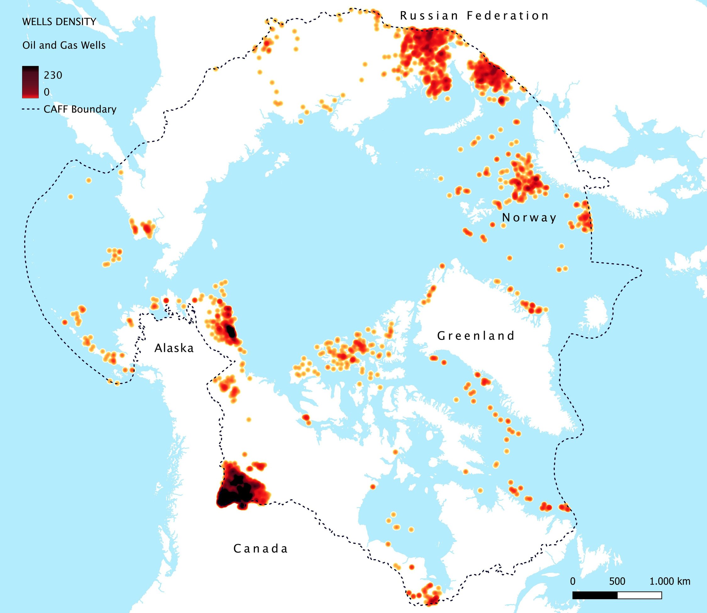
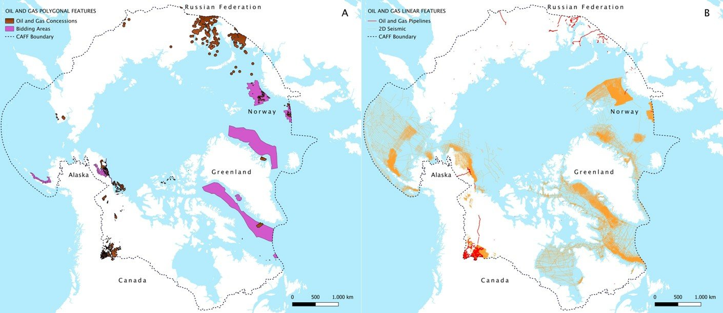
The study reveals the large spatial footprint of hydrocarbon development across the CAFF Arctic region:
- 512,306 km² of Arctic territory are currently covered by oil and gas licenses—an area comparable in size to Spain.
- The research identified 44,539 oil and gas wells, 39,535 km of pipelines, and nearly 1.95 million km of seismic exploration lines.
- Seismic exploration alone spans distances almost 48 times the circumference of the Earth, highlighting the intensity of exploration activities across the region.
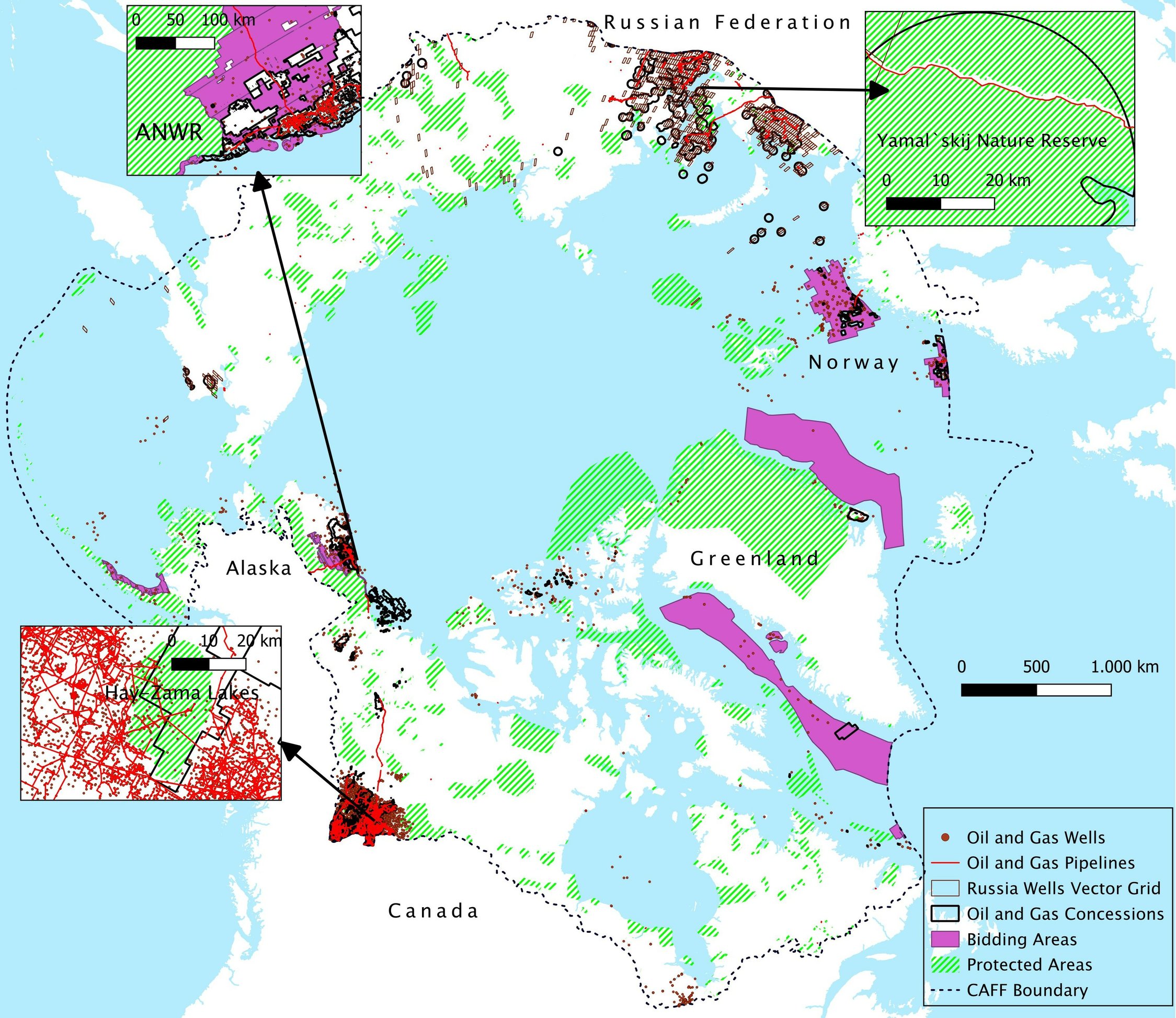
The spatial analysis also revealed significant overlaps with areas of ecological and cultural importance:
- 73.3% of Arctic oil and gas concession areas intersect with Indigenous Peoples’ lands.
- 7.57% of concessions overlap with protected areas.
- Many extraction zones also coincide with the habitats of key Arctic species, including polar bears, caribou, and yellow-billed loons.
Beyond direct overlaps, the study finds that a substantial number of wells and pipelines are located within close proximity to protected areas and Indigenous territories, pointing to potential socio-ecological pressures even where formal overlaps do not occur.
Geographically, the highest concentrations of extractive activity are found in regions such as Russia’s Yamal Peninsula, Canada’s western provinces, and Alaska’s North Slope: areas characterized by highly sensitive ecosystems and the presence of Indigenous communities.
Overall, the findings highlight and geovisualize the overlap between different strategies and plans for the management of territories and their natural resources. On the one hand, they reveal the interests of the oil and gas industry and its extractivist approach; on the other, they emphasize the importance, within the context of the climate crisis, of safeguarding the fragile functions and services of Arctic ecosystems through the cultural practices and knowledge of the marginalized Indigenous communities. While not all overlaps translate into immediate conflict, the proximity of industrial infrastructure raises concerns about long-term environmental degradation, cultural impacts, and governance challenges.
At the same time, the study identifies significant gaps in the availability and transparency of spatial data on Arctic oil and gas, particularly in Russia, complicating efforts to monitor environmental and social impacts. By compiling and systematizing a comprehensive set of geospatial data sources (all available in the Supporting Information of the paper), this research contributes to improving transparency and enabling more informed decision-making.
Future perspectives for Arctic research and policy: towards an Arctic Fossil Fuel Non-Proliferation Zone
In response to this evolving geopolitical context, the European Commission has launched a public consultation on the upcoming update of the EU Arctic Policy, expected in the third quarter of 2026. The consultation, which ended on March 16, aimed to gather input from stakeholders to inform the revision of the EU’s 2021 Arctic Strategy.
The Jean Monnet Centre of Excellence on Just Fossil Fuel Transition at the University of Padua was among over 1,600 individuals and organizations contributing to the consultation. In its submission, the Centre put forward a set of key recommendations:
- Strengthening science-based policymaking by integrating spatial assessments of environmental sensitivity, biodiversity conservation priorities, and Indigenous land use into policy frameworks
- Ensuring that Arctic governance frameworks fully respect Indigenous rights and enable meaningful participation in decision-making processes, in line with the principles of Free, Prior and Informed Consent (FPIC), the United Nations Declaration on the Rights of Indigenous Peoples, and ILO Convention 169.
- Reaffirming the core objectives of the 2021 EU Arctic Strategy, including maintaining peaceful and constructive dialogue and cooperation in a changing geopolitical landscape, addressing interconnected climate, and environmental challenges, and supporting inclusive and sustainable development for Arctic communities.
- Strengthening the EU’s commitment to the Paris Agreement and the European Green Deal by advancing a clear multilateral framework aimed at halting further hydrocarbon development in the Arctic and discouraging the import of such resources. The updated Arctic policy should establish a permanent ban on the exploration and extraction of oil, coal, and gas in Arctic regions, building on existing partial moratoriums on hydrocarbon exploration in the Arctic and defining concrete milestones to achieve these objectives.
The last recommendation strongly connects with the present study’s proposal to establish an “Arctic Fossil Fuel Non-Proliferation Zone”, a regional initiative aligned with global efforts to halt the expansion of fossil fuel production and phasing out the existing one, inspired by the principles of the Fossil Fuel Treaty Initiative and in line with similar proposals advanced for other critical regions such as the Amazon. Such an approach would place climate justice and Indigenous leadership at the core of Arctic governance. In this regard, the spatial justice considerations presented in the Arctic Atlas study add to the evidence (presented in Table 1) that makes the region an ideal candidate for the establishment of a Fossil Fuel Non-proliferation Zone.
| Table 1: Arctic Fossil-fuel Non-Proliferation Zone: evidence in favor of the establishment | |||
| Dimension | Key Evidence | Implication for Non-Proliferation | Reference |
| Climate constraints | Arctic oil and gas resources identified as incompatible with 1.5°C pathways; high-cost and high-carbon resources (e.g., Welsby et al. 2021) | Strong rationale for leaving Arctic hydrocarbons undeveloped (“unburnable/unextractable carbon”) | Welsby et al., 2021 |
| Economic and technical factors | High extraction costs, long lead times, technological complexity | Elevated risk of stranded assets; weak economic justification for new developments | Welsby et al., 2021 |
| Ecological and human vulnerability | Overlap and proximity between oil & gas, biodiversity hotspots, and Indigenous Peoples’ lands | Heightened environmental risks and justice concerns support precautionary approaches. Overlapping interests in territorial management are not always compatible. | Codato et al., 2026 |
| Infrastructural fragility | Large share of infrastructure located on thawing permafrost, increasing erosion and instability | Growing physical risks undermine long-term viability of fossil fuel projects | Hjort et al., 2018 |
| Existing policy precedents | Moratoria in Greenland, Canada, and the United States | Demonstrates political feasibility of restricting Arctic fossil fuel expansion | Government of Canada, Government of the United States, 2016 |
| International governance signals | European Union commitment to ensuring that fossil fuels are kept in the ground and exploring multilateral framework | Emerging foundation for coordinated non-proliferation approaches | EU Commission, 2021 |
| Climate justice and equity considerations | High responsibility and capacity of Arctic-producing states (e.g., US, Canada, Norway) | Normative basis for leadership in fossil fuel phase-out | Many studies (e.g., Civil Society Equity Review, 2023; Calverley and Anderson, 2022) |
From research to action: the Santa Marta conference 24-29 April 2026
The study is released ahead of the First Conference on Transitioning Away from Fossil Fuel, which will be held in Santa Marta (Colombia) at the end of April 2026. This conference represents a key milestone in advancing international dialogue on fossil fuel phase-out, bringing together governments, signatories of the Belém Declaration, academia, civil society, and Indigenous representatives to discuss pathways for a just and equitable transition.
The study contributes to the debate of the conference by supporting a spatial justice, geographical, approach to the theme of phasing out fossil fuels, based on Nature’s and Human rights: by identifying where oil and gas activities overlap with ecologically sensitive areas and Indigenous lands, the Arctic Atlas helps define not only when fossil fuels must remain unexploited, but also where restrictions should be prioritized based on spatial justice criteria.
Some of the paper’s authors will be present in Santa Marta in the different streams and events of the conference, contributing to the dialogue on the urgency of implementing fossil fuel phase-out from a situated perspective. ay April 29 the panel titled “Between Amazon and Arctic: Place-Based Pathways for Just Fossil Fuel Transitions” is organized by the Jean Monnet Centre of Excellence on Just Fossil Fuel Transition and the international research group “Climate Change, Territories, Diversity”.
During the panel, researchers and activists will discuss the tensions between extractive policies and community-based alternatives, highlighting how visual data can strengthen political advocacy and environmental justice in diverse territories that are shaping these transitions. Taking the Amazon and the Arctic as iconic regions of transformation, the dialogue transcends the local to explore “Yasunization” as a global phenomenon of social mobilization generated by a multitude of grassroots initiatives. The role of geovisualization tools in mapping the multitudes and narratives driving this change is explored.